
Yucatán Cadastral Certificate & Plan Requirements Checklist
An authoritative procedural guide and interactive checklist for obtaining a Cédula Catastral, Constancias de No Adeudo, official georeferenced survey plans, and boundary rectifications from the Dirección de Catastro of INSEJUPY.
Cadastral Certificate Checklist Builder
Select your required cadastral procedure in Yucatán and generate an interactive preparation checklist with verified document requirements.
All checkbox states are stored locally in your browser's memory. No property data, names, or file selections are transmitted to any server.
The Role of Catastro in Yucatán Property Governance
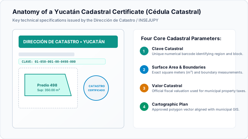
While the Public Registry of Property (RPP) holds legal sovereignty over ownership titles, deeds, and encumbrances, the Dirección de Catastro is responsible for the technical and physical reality of the land. Under the Ley del Catastro del Estado de Yucatán, the cadastre manages the cartographic, geodetic, and fiscal valuation inventory of all real estate situated within the 106 municipalities of Yucatán.
Without an updated, certified Cédula Catastral that perfectly matches the physical measurements on the ground, a Notario Público cannot legally execute a deed transfer, a bank will refuse to underwrite a mortgage, and the municipality will deny municipal construction permits (Licencia de Construcción).
Essential Cadastral Milestones
- Cédula vs. Escritura Alignment: The measurements and boundaries (medidas y colindancias) listed on the Cédula Catastral must match the physical deed exactly. If there is a discrepancy greater than statutory tolerance limits, a formal Rectificación de Medidas must be filed.
- Valor Catastral Determines Tax Floors: The official fiscal assessment (Valor Catastral) calculated by Catastro forms the minimum legal floor for municipal ISAI taxes. A property cannot be transferred at a fiscal price lower than its cadastral valuation.
- State Catastro vs. Mérida Municipal Catastro: Properties located in the Municipality of Mérida are managed directly through the Catastro Municipal de Mérida (Calle 73 x 44 y 46, Centro), whereas rural municipalities and coastal towns without autonomous cadastral offices are administered directly by the Dirección de Catastro of INSEJUPY.
Statutory Turnaround Times and Fee Tariffs (2026 UMA Schedule)
Cadastral service tariffs are calculated in Unidades de Medida y Actualización (UMA) under the State and Municipal Finance Laws:
| Cadastral Procedure | Purpose & Use Case | Estimated Tariff (MXN) | Processing Window |
|---|---|---|---|
| Cédula Catastral Definitiva | Official plot ID card required for deed closings and bank underwriting | $1,850 to $2,800 MXN | 5 to 8 business days |
| Copia Certificada de Plano Catastral | Official georeferenced polygon diagram aligned with satellite GIS mapping | $950 to $1,500 MXN | 3 to 5 business days |
| Constancia de No Adeudo Predial | Certification confirming zero arrears on municipal property taxes | $450 to $650 MXN | 1 to 3 business days |
| Oficio de División / Fusión de Predios | Subdivision or lot unification authorization required for developments | $4,500 to $12,000+ MXN | 15 to 25 business days |
| Rectificación de Medidas y Linderos | Legal boundary correction when survey differs from historic deed | $3,800 to $7,500 MXN | 20 to 30 business days |
Top 4 Reasons for Cadastral Rejection or Suspension
-
1
Boundary Overlap with Adjacent Plots (Sobreposición de Linderos)
When the surveyor georeferences the coordinates into the state cadastral GIS database, if the perimeter overlaps an existing neighbor polygon, the procedure is suspended until a joint boundary act (Acta de Deslinde y Avenencia) is signed.
-
2
Unrecorded Home Expansions or Renovations
If satellite aerial inspection reveals a swimming pool, second story, or additional rooms not documented on the prior cadastral cédula, an inspection perito will visit and assess back taxes (Regularización de Construcción).
-
3
Mismatched Spelling on Registered Deeds
Even a single typo in a maternal surname or street number between the deed and cadastral filing prompts an administrative suspension requiring a formal clarifying certificate (Certificado Aclaratorio).
-
4
Non-Certified Surveyors (Perito Valuador No Registrado)
Only topological surveys signed by a licensed surveyor registered in the Padrón de Peritos Valuadores de Yucatán are legally accepted by Catastro and INSEJUPY.